 |
| Kyle and Megan at the summit of Silver Star Mountain with Mt. St. Helens in the background |
Time: 2.5 hours
Distance: 4.8 miles
Difficulty: Moderate, but technical
Stars: 4
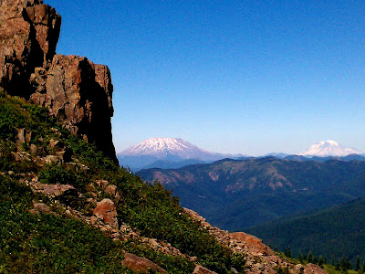
The author of our book recommend we do this hike on a clear day because there is a possibility to view Mt. Hood, Mt. St. Helens, Mt. Rainier, Mt. Jefferson, Mt. Adams, the Portland area, and the Columbia River Gorge area. The weather was nice and warm, but extremely windy, with a clear view to the north. Unfortunately, the view to the south was cloudy, so we didn't get to see Mt. Hood, Mt. Jefferson, the Portland area, or the gorge. It was still very worth it.
 |
| View of Mt. St. Helens from the car, with Kyle's famous monkey in the foreground! |
The drive to the trailhead was an interesting one, to say the least. There were views of Mt. St. Helens while driving out there, and then we drove about 9 miles in 35-40 minutes because it was a narrow, bumpy, gravel road.
 |
| Old Jeep road as the trail, with the spur ahead of us. There were steep drop offs to the north and south of the spur. |
There was a beautiful view of Mt. St. Helens from the trailhead, and our trail was heading uphill, so we knew it was only going to get better. Silver Star Mountain got its name because it looks like a star with 5 "spurs" connecting at the summit when viewed aerially. There are different trails to get to the summit, taking different spurs to get there. The trail started off steep and uphill (probably the steepest part of the trail) and was covered by small tress and shrubs so we were sheltered from the wind. After about a half mile, the trail opened up onto an old Jeep road and that was when we were first hit by the wind. We detoured off the old Jeep road and took Ed's Trail on the north side of the spur. Ed's Trail is probably the best and most interesting trail we have hiked yet.
The reason Kyle and I decided to call this trail "technical" is because there were some tricky spots. The trail was definitely on an edge, and one wrong move could have sent us tumbling down into a valley far below us. There were also parts that were very rocky, so we were stepping on loose, large slabs of rock. Kyle and I, of course, climbed up one of those rocky areas to check out the view. Before we were offered our first view of the summit of Silver Star, we had to climb almost vertically up the trail. It was definitely awesome! There was also a cool arch formation made from the rocks and a small cave.
 |
| View of the valley between 2 of the spurs! And we were headed towards that cliff face on the right of the valley! |
 |
| Trying to demonstrate how windy it was... |
 |
| Looking down at the "trail" we just climbed |
 |
| View of the rock formation Kyle and I climbed, with the rocky trail visible on the right. Beautiful views of Mt. St. Helens and Mt. Rainier in the background |
 |
| The arch! It looked like the rocks were glued together! |
 |
| Kyle finishing one of the rocky portions of the trail |
Ed's Trail eventually joins back up with the old Jeep road trail near the top (we took this way back down because it is easier and safer). The trail comes to a fork with an option of either continuing uphill to the north or south. The "official" summit is to the north with views of Mts. St. Helens, Rainier, and Jefferson, plus views of the trail we just hiked. The view to the south would have offered views of Mt. Hood and the Gorge, but unfortunately, it was still cloudy.
 |
| View of the spur from the summit! |
 |
| Ed's Trail is visible on the left in the middle (between the 2 clumps of pine trees). The trail continues to the right of the photo, onto and down the rocky areas |
 |
| Kyle resting at the top with Mt. Adams on the horizon |
We ate a snack at the top, took some pictures, and then headed back on the easier trail. On our way up, when we first spotted the actual summit of Silver Star, we both thought no way was that where we were headed! It seemed so far away and so much higher! So on our way back down I snapped a picture of the summit:
 |
| Silver Star Mountain summit at 4390' |
Overall it was a great hike! We only gave it 4 stars in part due to the clouds we encountered to the south and the wind making for a tough hike. The views of the 3 mountains we saw were fantastic, but since Mt. Hood is my favorite mountain of all time (currently, who knows if I travel and get to see more!) I was bummed that I didn't get to see it.
 |
| Megan on a small rock outcropping offering optimal views of the three volcanoes! |
There is another hike in our book that ends at the summit of Silver Star, but it takes a different spur to get to the top. The hike also passes by a couple of the other smaller mountains in the area and is a total of 13.5 miles. So hopefully, when we decide to tackle that hike, we go on a day when we can see Mt. Hood, Mt. Jefferson, and the Columbia River Gorge area better.
PS. Sorry for the poor photo quality. Again, we had to use our phones...lame! We are still working on buying a nice camera!

No comments:
Post a Comment